Happy Meteorological spring! Unfortunately, we will have some colder air to begin the week before we turn more springlike by the end of the week.
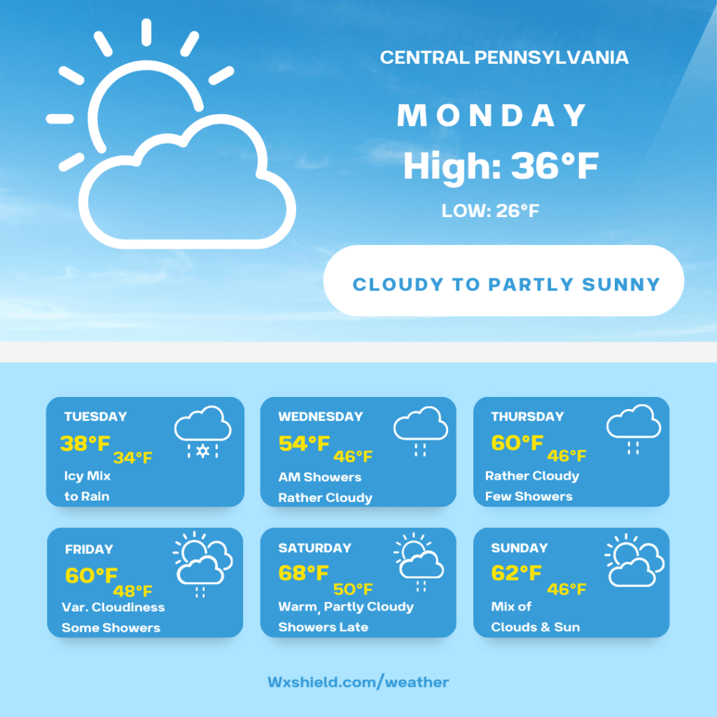
Monday morning temperatures will be in the upper teens. Winds will be from the north between five to ten mph. Monday morning, we will have patchy clouds.
Monday afternoon temperatures will reach into the mid to upper 30s. During the afternoon hours we will have a mix of clouds and sunshine. Winds will be from the southeast between five to ten mph.
Monday night temperatures will be in the upper 20s. Winds will be from the south between five to ten mph. Monday night we will be partly cloudy at first, but clouds will increase, and a wintry mix will develop into Tuesday morning. I am hoping it holds off, so we can see the full Worm Moon and total Lunar Eclipse early Tuesday morning. The full moon will be at its peak at 6:38 am EST on Tuesday morning.
Tuesday looks to be difficult to travel in the morning hours. It is a still a few days away, but you want to use caution. A low-pressure system from the south will move in bringing what looks to be freezing rain or an icy mix to the morning commute. As the day goes along, it will turn to a plain rain. Be careful and watch for slick and changing conditions. High temperatures on Tuesday will be in the upper 30s to lower 40s. Winds will be from the southeast between five to ten mph. Tuesday night temperatures will not fall far and will be stuck in the 30s.
On Wednesday high temperatures will rebound into the lower to mid 50s. It will be feeling like spring. We will have some morning showers, otherwise a cloudy day. Winds will be light from the south. Wednesday night temperatures will be in the mid to upper 40s.
Thursday the showery spring like pattern persists. High temperatures on Thursday will be in the upper 50s to lower 60s. Winds will be from the west between five to ten mph. Thursday will be rather cloudy with a few showers. Thursday night temperatures dip into the mid to upper 40s.
Friday high temperatures will be in the upper 50s to lower 60s. We will have clouds mixing with some sunshine. Once again, a few showers cannot be ruled out. Winds will be from the west between five to ten mph. Friday night temperatures dip into the upper 40s.
Saturday looks to be quite mild. Temperatures ahead of a cold front will soar into the mid to upper 60s. Winds will be from the west southwest between ten to fifteen mph. On Saturday we will have a mix of clouds and sunshine. Late in the day on Saturday the cold front arrives bringing in scattered showers and maybe even a rumble of thunder. Saturday night temperatures drop into the upper 40s to lower 50s.
Sunday high temperatures will be in the lower 60s. Winds will be from the west and will be light. On Sunday there will be times of clouds and sunshine. Low temperatures Sunday night will be in the 40s.
It looks like Monday we will also reach the 60s with a mix of clouds and sun.
Have a wonderful week!

Leave a comment