Happy Sunday! I hope you have had a nice weekend so far! Make sure to go outside and enjoy the weather today. We will be warming up this week, however a very showery pattern is setting up. You know what they say, “April Showers Bring May Flowers!”
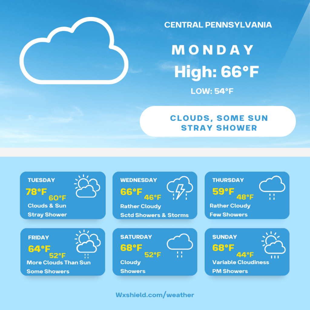
Monday morning we will be mostly to partly cloudy. Temperatures Monday morning will be in the mid 40s. Winds will be from the southwest between five to ten mph.
Monday afternoon we will have clouds mixing with some sunshine. A shower cannot be ruled out, but most of us stay dry. High temperatures will reach the mid to upper 60s. Winds will be from the southwest between ten to fifteen mph.
Monday night temperatures fall into the mid to upper 50s. We will be cloudy and there will be a shower or two around. Winds will be from the west southwest between ten to fifteen mph.
Tuesday there will be a southwesterly breeze between ten to fifteen mph. This will usher in warm air. High temperatures will reach the mid to upper 70s. Tuesday there will be clouds mixing with sunshine. A shower cannot be ruled out, but there is a better chance to see showers and even a rumble of thunder Tuesday night into Wednesday morning. Temperatures Tuesday night will be in the upper 50s to lower 60s.
Wednesday a cold front will make its way through, and then stall just to our south keeping us in a showery weather pattern. Timing of this front is still not 100% clear, so Wednesday expect scattered showers and storms. Ahead of the cold front, temperatures will reach the upper 60s. Winds on Wednesday will be from the west between ten to fifteen mph. Wednesday night temperatures will be in the mid to upper 40s.
Thursday we will have more clouds compared to sunshine. The front will stall just to our south. This makes for a tricky temperature forecast into the weekend. If clouds break on Thursday, Friday, and Saturday, temperatures could climb. If we stay cloudy with numerous showers we will be cooler. Make sure to stay up to date with the forecast. High temperatures right now on Thursday look to be in the upper 50s. Once again, a shower cannot be ruled out. Thursday night temperatures will be in the 50s with showers.
Friday we will have a variable cloudy sky with scattered showers. High temperatures on Friday will be in the 60s. Winds will be from the west southwest between five to ten mph. Friday night we will have a cloudy sky with a shower or two. Temperatures Friday night will be in the 50s.
Saturday there will be an overcast sky with shower, maybe even a rumble of thunder. High temperatures on Saturday will be in the upper 60s to lower 70s. Winds will be from the southeast between five to ten mph. Saturday night temperatures will be in the 50s.
Sunday for Easter, we will have a cold front moving through that will start to change our weather pattern. High temperatures for Easter will be in the 60s. Winds will be from the south between ten to fifteen mph. We will have clouds increasing with a line of showers and storms moving through. Sunday night the showers taper off. Temperatures Sunday night will be in the 40s.
Monday clouds break for some sunshine. It will be cooler behind the cold front. High temperatures on Monday will be in the upper 40s to lower 50s. Winds will be from the west northwest between ten to fifteen mph. Monday night will be clear as temperatures drop into the 30s.
Have a great week!

Leave a comment