Happy Sunday! I hope you have had a wonderful weekend so far! I know we have been quite productive! This week we are going to see temperatures soar to start the week, and then more seasonable air returns into Memorial Day Weekend.
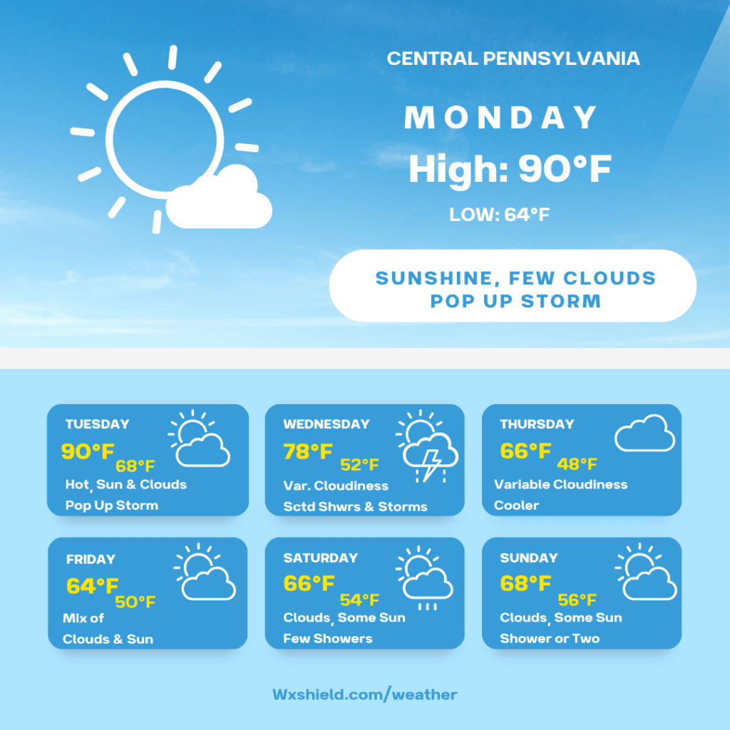
Monday morning we will have a few clouds around. Temperatures will be in the upper 50s to lower 60s. Winds will be calm to light from the southwest.
Monday afternoon we will have sunshine with just a few passing clouds. Temperatures will soar into the upper 80s to lower 90s. Our record high temperature for this date is 91 degrees back in 2017. Due to the heat and humidity, we could see a pop up storm during the daytime hours. Winds will be from the southwest between five to ten mph.
Monday night temperatures will be in the mid to upper 60s. Winds will be from the southwest between 3-5 mph. We will have a partially clear sky.
Tuesday we will have sunshine mixing with some clouds. Once again, with day time heating and humidity, we could have a pop up afternoon thunderstorm, but most will stay dry. Record high temperature for Tuesday was 92 degrees in 1996. We will see temperatures soar into the upper 80s to lower 90s, so we do have the chance to break a record. Winds on Tuesday will be from the west southwest between ten to fifteen mph. Tuesday night temperatures will drop into the mid to upper 60s with patchy clouds.
Wednesday a cold front will be rolling across Central PA. This will get us out of the hot and humid weather pattern. High temperatures on Wednesday will be in the upper 70s. If we see more in the way of sunshine, we may reach the lower 80s. There will be scattered showers and storms Wednesday. If we do have more sunshine, some storms could contain some gusty winds. You’ll want to stay weather aware. Winds on Wednesday will be from the west between ten to fifteen mph. Wednesday night temperatures will dip into the lower to mid 50s.
Thursday high temperatures will be in the mid to upper 60s. It will be a cooler day with lower humidity. Thursday we will have more clouds compared to sunshine. Winds will be from the east northeast between five to ten mph. Thursday night temperatures will dip into the mid to upper 40s.
Heading into Memorial Day Weekend, weather models start to disagree a bit. GFS keeps us with a rainy pattern, while the Euro keeps the rain to our south. Right now, my plan is to split the difference, but you’ll want to stay up to date with the forecast because there will be adjustments.
Friday right now looks to be on the cooler side. High temperatures will only make it into the lower to mid 60s. Winds will be from the east between five to ten mph. Friday we will have a mix of clouds and sunshine. A shower or two is possible. Friday night temperatures will be in the lower 50s.
Saturday we will have high temperatures in the upper 60s. Winds will be from the southeast between five to ten mph. Saturday we will have a few showers around. Saturday night temperatures will be in the mid 50s.
Sunday there will be more clouds compared to sunshine. High temperatures will reach the upper 60s to lower 70s. Winds will be from the south between five to ten mph. Once again, a few showers are possible.
Memorial Day high temperatures will be in the lower 70s which is seasonable. Winds will be from the south between five to ten mph. On Memorial Day we will have a mix of clouds and sunshine. There could be a shower or storm in spots.
Have a wonderful week ahead! Stay cool!

Leave a comment