Happy Sunday!
A cold front moving through today could bring strong to severe storms with downpours and damaging winds. You’ll want to stay weather aware today. The start of the week then becomes quieter before strong storms are possible again Thursday.
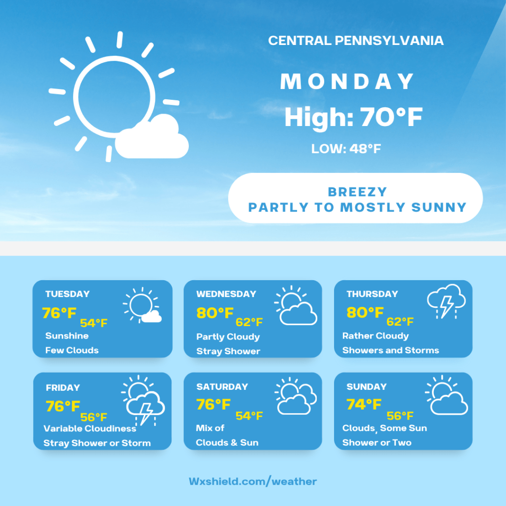
Monday morning temperatures will be in the mid to upper 50s. Winds will be from the west between five to ten mph. Monday morning we will have more clouds compared to sunshine.
Monday afternoon we will have a partly to mostly sunny sky. High temperatures on Monday will be in the upper 60s to lower 70s. Winds will be from the northwest between ten to fifteen mph. Gusts could be up to 25 mph.
Monday night we will have a mainly clear sky. Monday night temperatures will dip into the mid to upper 40s. Winds will be from the west between five to ten mph.
Tuesday we will have sunshine with a few clouds. High temperatures on Tuesday will be in the mid to upper 70s. Winds on Tuesday will be from the southwest between five to ten mph. Tuesday night we will have a partially clear sky. Temperatures will dip into the lower to mid 50s.
Wednesday we will have a mix of clouds and sunshine. A shower cannot be ruled out during the afternoon hours. High temperatures on Wednesday will be in the mid to upper 70s. Winds will be from the southwest between ten to fifteen mph. Wednesday night we dip into the lower 60s. Wednesday night into Thursday morning there will be some showers and storms.
Thursday we will be cloudy with storms. Some storms could contain gusty winds and downpours. We are still far out from Thursday, but it is a day to stay up to date with the weather for. Winds on Thursday will be from the west southwest between ten to fifteen mph. Thursday night temperatures dip into the lower 60s.
Friday we will have a variable cloudy sky. Friday there will be a shower or two around. Friday high temperatures will be in the edit o upper 70s. Winds will be from the west northwest between five to ten mph. Friday night temperatures dip into the mid to 50s.
Saturday there will be a mix of clouds and sunshine. High temperatures on Saturday will be in the mid to upper 70s. Winds will be from the west between ten to fifteen mph. Saturday night temperatures will dip into the lower 50s.
Sunday high temperatures will be in the lower to mid 70s. We will have a shower around, otherwise a mix of clouds and sunshine. Sunday night temperatures dip into the lower to mid 50s.
Monday high temperatures will be in the upper 70s with clouds and sunshine.
Have a wonderful week!


Leave a comment