Happy Father’s Day out there to all the dads, grandpas, uncles, cousins and father figures! Today is also the first day of astronomical summer. The summer solstice took place at 4:24 am this morning. We will have a very seasonable week to kick off summer.
Today sun will slowly fade behind the clouds as a low pressure system moves in. It will be a great day to head outdoors! Temperatures will reach the upper 70s.
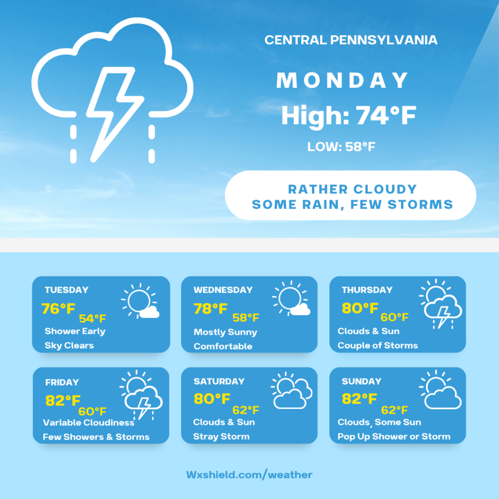
Monday the low pressure system arrives. We will be cloudy and more humid on Monday. Monday morning temperatures will be in the upper 50s to lower 60s. We will start the day with times of rain. Some pockets of rain throughout the day could be downpours, and in areas of poor drainage we could see pooling of water. If you come across a road covered in water, turn around and take a different route.
Monday afternoon we stay rather cloudy with some showers and storms. Any storm again could contain gusty winds and downpours. High temperatures on Monday will be in the mid 70s. Winds will be from the southeast between five to ten mph.
Monday night we will see showers tapering off. Temperatures will be in the upper 50s.
Tuesday very early we could see a lingering shower. The rest of the day the sky will be clearing for plenty of sunshine. High pressure will be building in. High temperatures on Tuesday will be in the mid 70s. Winds will be from the north northwest between five to ten mph. Tuesday night expect a clear sky with low temperatures dipping into the lower 50s.
Wednesday high pressure stays with us. We will have plenty of blue sky and sunshine. There will be just a few passing clouds. High temperatures on Wednesday will be in the upper 70s. Winds will be from the west northwest between five to ten mph. Wednesday night temperatures will fall into the mid 50s.
Thursday we start a more summer like weather pattern. Each day into the weekend we will have chances for a few showers and storms, but most people stay dry. It will also be warmer with more humidity. High temperatures on Thursday will be in the lower 80s. Winds will be from the south between five to ten mph. Thursday we will have a mix of clouds and sunshine with a couple of storms around. Thursday night temperatures will dip into the upper 50s to lower 60s.
Friday high temperatures will be back into the lower to mid 80s. Winds will be from the west between five to ten mph. Friday there will be clouds mixing with some sunshine a few showers and storms. I do think we could see more showers Friday night into early Saturday morning. Temperatures Friday night will be in the lower 60s.
Saturday high temperatures will be near the 80 degree mark. Winds will be from the west northwest between five to ten mph. Saturday we will have a partly cloudy sky with a stray shower or storm. Saturday night temperatures will be in the lower 60s.
Sunday high temperatures will be in the lower 80s. Winds will be from the west between five to ten mph. Sunday we will have clouds and sun with a pop up shower or storm. Low temperatures will dip into the 60s.
The following Monday is looking dry with high temperatures in the mid 80s. We will see a mostly sunny sky.
Have a great rest of your weekend and enjoy the week ahead!

Leave a comment