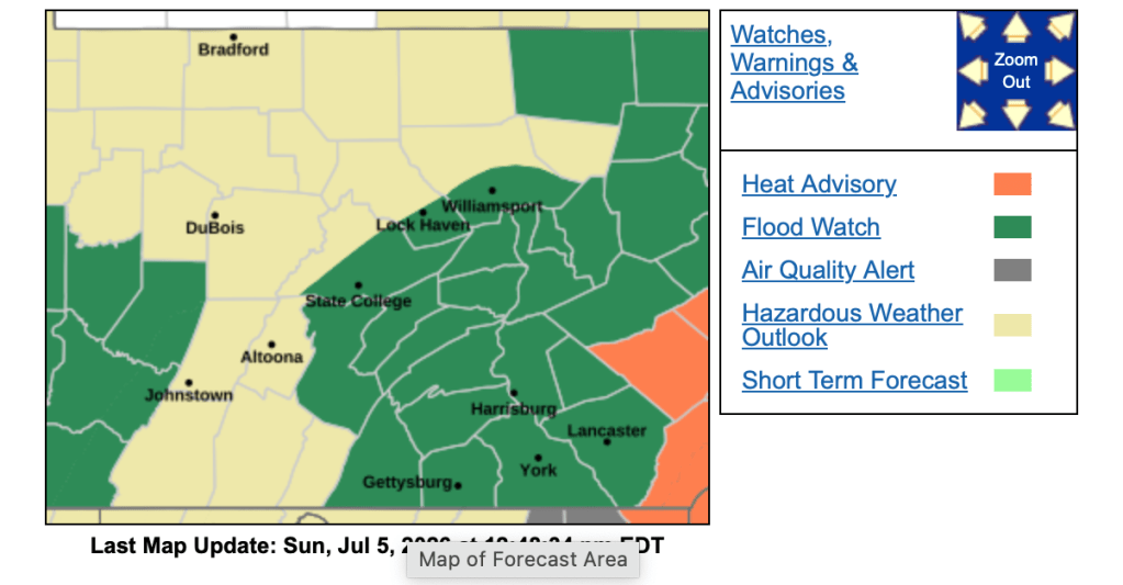
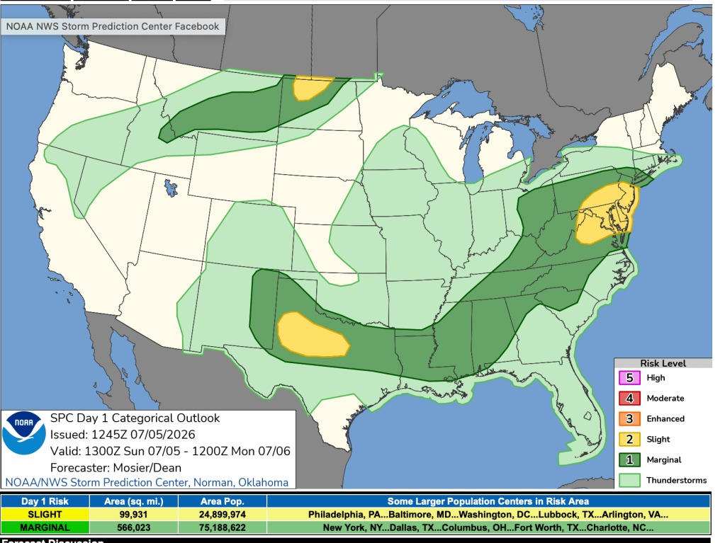
Happy Sunday! I hope you all had a wonderful 4th of July. Today we will be dealing with scattered gusty thunderstorms that could bring flooding downpours. Please keep up with the weather today. Due to this, the National Weather Service has issued a Flood Watch for counties shaded in green. The Flood Watch continues into Monday afternoon. Also, we are under a slight risk of severe storms.
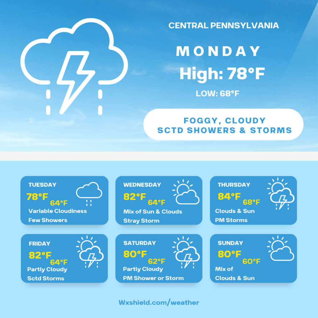
Monday morning temperatures will b min the mid to upper 60s. Winds will be light and variable. During the morning hours we will be foggy with showers and storms.
Monday afternoon there will be a few showers and storms. Some once again could have heavy rainfall. If you come across a road covered in water, turn around and take an alternate route. Otherwise, Monday will be cloudy. Temperatures will be in the upper 70s to near 80 degrees. Winds will be from the east between five to ten mph.
Monday night temperatures will dip into the mid to upper 60s. It will be a muggy night. Winds will be light from the east. We will have a cloudy sky and a shower or storm cannot be ruled out.
Tuesday high temperatures will be in the mid to upper 70s. Winds will be light from the east. We will have variable cloudiness with a few showers. A rumble of thunder or two cannot be ruled out. Tuesday night temperatures will be in the lower 60s.
Wednesday looks to be our drier day of the week. Temperatures on Wednesday will be in the lower 80s. Winds will be from the east between 3-5 mph. Wednesday we will have a mix of sun and clouds. During the afternoon hours a stray storm is possible. Wednesday night temperatures will be in the 60s.
Thursday will be a typical July day. High temperatures will be in the lower to mid 80s. We will have winds from the west between five to ten mph. Thursday there will be a mix of clouds and sunshine. By Thursday afternoon, we will see some showers and storms pop up. Thursday night temperatures will be in the upper 60s.
Friday temperatures will be in the lower 80s. We will have a partly cloudy day with scattered showers and storms. Winds will be from the west between five to ten mph. Friday night temperatures will be in the 60s.
Saturday we will have high temperatures in the upper 70s to lower 80s. Saturday we will have clouds and sun with scattered afternoon showers and storms. Winds will be from the east between five to ten mph. Saturday night temperatures will be in the lower 60s.
Sunday high temperatures will be in the lower 80s. Sunday we will have a partly sunny day. Winds will be from the northwest between five to ten mph. Sunday night temperatures will dip into the upper 50s to lower 60s.
Monday temperatures will be in the lower 80s. Monday we will have a westerly wind between five to ten mph. Monday we could see an afternoon pop up storm.
Have a good week!
Almanac for today (Altoona records since 1948):
Average High: 83°F
Average Low: 62°F
Average Precip: .11″
Record High: 97°F in 1944
Record Low: 42°F in 1979
Record Precip: ” 1.25 in 1949
Yesterday’s High: °F
Yesterday’s Low: °F
Yesterday’s highest wind speed:
Sunrise: 5:49 am
Sunset: 8:46 pm

Leave a comment